Airways Connectivity In North Eastern Region of India
Dr. Kalidas Sarma (PDF Fellow), Dr. Narayan Chetry
 Connectivity means opening up the international borders to the immediate neighbourhood and beyond, based on which the progress of a region takes place. Connectivity, mainly pertaining to transport and communication is a fundamental requisite element of infrastructure, peace and development in a region. All of these three aspects of a region should be concurrent and not sequential. The North Eastern Region (NER) has an extensive network of airport and air fields which are legacy of the Second World War (WW-II). It was only after independence that the Ministry of Civil Aviation and North Eastern Council initiated the process to develop a good infrastructure of airport connectivity in the region, although there are still gap areas which need further development. Significant improvements can be noticed in this regard within mainland India, but inter-regional connectivity is still poor, in fact there is a decrease in air services from 17 (seventeen) in 1970s to 11 (Eleven) at present.
Lokpriya Gopinath Bordoloi International (LGBI) airport is the only International Airport running in the region. It received 2.2 million domestic and international passengers during 2011-12. There are other 5(Five) out of 19 (nineteen) domestic airports which are currently in operation in the NER. Unfortunately, India’s north east air transport system is still poorly developed due to insufficient infrastructure. Geo-political and socio-economic factors play an important role for the backwardness in this regards.
The barriers and opportunities of geographical setting for connectivity
Geographically, the region constitutes the seven states of Arunachal Pradesh, Assam, Manipur, Mizoram, Nagaland and Tripura. Sikkim has become eighth member under the NEC since 2002 after restructuring the regional planning body. Flanked by the hills along its north and south course, the mighty Brahmaputra River slashes a central path through the vast plain, forming the main artery and life line of NER. It is navigable from Pashighat in Arunachal Pradesh through Sadiya in Assam to the Bay of Bengal. This connectivity by waterways was exploited during the British regime but it is disheartening to note that it is not being utilized during independent governance in India. Over 98 percent of Northeastern state boundaries are international borders measuring about 5,437km in length. The NER constitutes 8 percent of India’s total geographical area and more than two third of its area (about 72%) is under hills, mountains and plateaus leaving only about 28 percent in plain area. At the same time, of the 72 percent hilly terrain, three-fourth has steep slope, deep gorges and ravines, where laying of road ways and railways are very much challenging. Isolation of India’s north east from main land is another factor for its backwardness.
For utilization of northeast’s strategic significance a strong airway linkage is felt very necessary to strengthen inter- regional coordination for regional development to ensure friendly inter-state border peace, cohesion, connectivity, inclusive development and economics of scale. Travel and tourism is an important activity of human beings from time immemorial and can be called the industry of the present and future.
Described as cul-de-sac surrounded by four foreign countries of Bhutan, Bangladesh, Myanmar and China, connecting this region through road ways and railways are not sufficient enough to fulfill the gap of interregional connectivity and cultural integration of the diverse social groups inhabiting the region. Another hindering cause for stagnation of surface transport networks is the heavy rainfall for more than six months of the year leading to gully erosion. Loose soil base derived from alluvium soil leads to massive landslide, creep in the hilly region and numerous turbulent rivers and hill streams which change their course frequently leading to huge expenditure in repairing bridges, culverts, retention walls and spurs. Viewing the existing physiographic problems in the region, there is an opportunity to open the door of air connectivity for faster travel. The terrain makes air connectivity not just an option but an absolute necessity for tourism and economic development. Road and railways are highly capital intensive than development of air infrastructure. The other need for air connectivity is the faster movement of perishable agro-commodities and for cargo to find quick and reliable market within and outside state. A seamless border with Bengal, Bhutan and Myanmar, access to the ravine and overland routes of communication ensured that the region began to emerge as major hub of economic activity. North East India which has nearly 45 million people, that is 4 percent share of India’s population, can be called home of 220 diverse ethnic groups and communities of India. The neighbouring countries of the region constitute a market of about 2.81 billion people which is roughly 40% of the world population. The region is also blessed with rich natural resources accounting for 34 percent of the country’s water resources, possessing 40 percent of India’s hydro-power potential and can easily be India’s portal to the east. It can become the new growth engine for the country. North east India has its definite identity due to its peculiar physiographic, economic and socio-cultural characteristics and has the potential of transforming the region into a zone of economic concentration. Based on this scope, the NER can be transformed into a trading and commercial hub of southeast Asia. Developing some cities and cultural sites can transform the region as a tourist hub for which air connectivity will give a boost for faster growth and development. India’s trade with its neighboring countries such as Nepal, Bhutan, Bangladesh, Cambodia, Lao PDR, Myanmar, Thailand and Vietnam has grown from INR 81,385 crores in 2009-10 to INR 184, 687 crores in 2013-14 at a compound annual growth rate (CAGR) of 23%. But despite of the regions proximity to these countries, the share of North East India in this trade has been consistently hovering in the range of 1 to 2 percent, which is contributing only 5 percent of the total export to Bangladesh, Bhutan and Myanmar. With the above circumstances, expansion of air-transport is felt urgent to integrate the region for its socio-economic prospects.
next
-
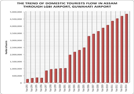
Fig.1: The trend of domestic tourist flow in Assam, 1993-2014
Source : Office of the Directorate of Tourism, Govt. of Assam
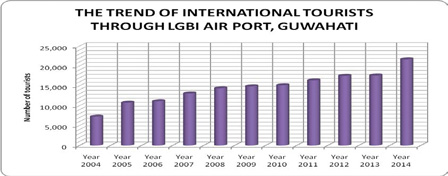
Fig.2: The trend of international tourist flow in NER, 2004-2014
Source: Office of the Directorate of Tourism, Govt. of Assam
Prior to independence, this region was amongst the most industrially developed region in the country because of its rich natural endowment. Tea plantation and tea manufacturing, plywood manufacturing, coal mining and oil refining were some prominent industrial units that exist from the British period, but after partition of the country NER’s socio-economic structure was crippled significantly when it lost its connectivity and market access and the region was virtually sealed and found to be hostile on all sides. It is to be mentioned here that the narrowness of the 22 km connecting link called the chicken’s neck (through Siliguri) with mainland India has proven to be a stumbling block for development of the region.
Given its geographical position, long international border with countries such as Myanmar, Bhutan, Bangladesh and China, proximity with the ASIAN countries and its richness in natural resources, the North Eastern Region can be transformed as a hub of economic activity and trade for India and its sub –region. This can be achieved only through restoring connectivity linkages. Development of air-transport in the region is an alternative to transform the region into Economic Corridor connecting India, Myanmar, Bangladesh, and ASEAN countries through easy access. This transformation will have a multifaceted impact not only in India but the entire sub-region. This will ultimately pave the way for the integration of the region with the outside world too. To reach this destination, there is an urgent need to see the existing level of airways connectivity for the faster integration and socio- economic development of the India’s north east.
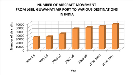
Fig. 3: The trend of aircraft movement from LGBI, Guwahati
Source: Director of (Infrastructure), Civil Aviation, Ministry of development of NER
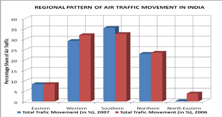
Fig. 4: Regional patterns of Traffic movement in India -2006-2007
Source: Public Information Domain, web site: www.aai.aero
Air connectivity as a means of social cohesion and economic development
For utilization of northeast’s strategic significance a strong airway linkage is felt very necessary to strengthen inter- regional coordination for regional development to ensure friendly inter-state border peace, cohesion, connectivity, inclusive development and economics of scale. Travel and tourism is an important activity of human beings from time immemorial and can be called the industry of the present and future. The travel and tourism industry has become globally the fourth largest industry and total contribution to worldwide Gross Domestic Product (GDP) is estimated at 9 percent over the decade. In the case of India, it is generating about more than $100 billion and is expected to increase to $ 4, 275.5 billion by 2018 at a 9.4 percent annual growth rate. Transformation of world as a global home has resulted in faster mobility of the human being than earlier times. Henceforth, time factor becomes precious to the context of economy. Preference of air-transport amongst tourists is becoming inevitable particularly in a region like Northeast India. So, for the faster growth of socio- economy of a region, revamping of airways connectivity is becoming imperative.
The pattern of domestic and international tourist flow in NER
From the graphics of tourist flow in the NER (as depicted in Fig. 1 and Fig. 2), it is observed that the domestic and the international tourists flow in NER through Assam has gradually increased from 2006 onwards. In the case of domestic tourists, there is a faster rate of increase in volume than the international one. By taking into consideration the flow of foreign tourists in the region, it has been observed that in the year 1993, the tourists that arrived in the region was 1083 persons but in the year 2000, it has gone to 5, 959 persons. Although in 1995 to 2004 foreign tourists arrival was constant around 15,000 to 17,000, but there has been a radical change in the year 2014 and the figure stood at 21,000.
The trend of aircraft movement in NER during 2004 - 2011
In respect of the trend of aircraft movement from LGBI Guwahati airport to various destinations in India during 2004 - 2011 (as represented by Fig. 3), it is observed that there is a gradual rise in the volume of aircraft movement. The volume of increase in aircraft movement in 2010-2011 in relation to 2004-2005 is 104 % that is a more than double rise during these six years.
This growth towards faster movement of goods and passengers from various parts of India in the NER is an indication of positive development of air connectivity in the region.
The regional pattern of traffic and passenger movement in India
The regional pattern of traffic and passenger movement in India is quite imbalanced. While comparing this regional pattern, (as represented by Fig. 4 and Fig. 5 respectively), it has been observed that the level of air connectivity in the western, southern and northern regions of India is higher than the eastern and north eastern region. Out of 5 air traffic zones of India, the NER handles insignificant volume of traffic and passenger as compared to other regions of India. The southern and western region of India play a key role in handling air and passengers traffic.
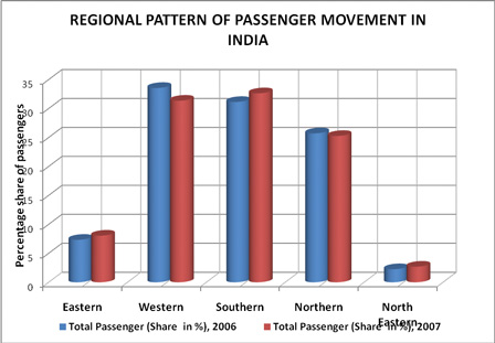
Fig.5: Regional pattern of passenger movement in India from 2006-2007
Source: Public Information Domain, web site: www.aai.aero
Table -1 : DATA PROFILE OF AAI AIRPORT AND CIVIL ENCLAVES
No State Airport Code Status No. of plane Dimension in mtrs Apron Capacity Apron Capacity Area in sqm North Eastern State 1 Arunachal Pradesh Tezu 3D Non-opl - 1500x30 2 - - 2 Passighat 2B Non-opl Dom 100x18 2 - - 3 Daparizo 2B Non-opl Dom 100x27 - - - 4 Assam Guwahati 4D Opl. Intl 3103x45 20 19(C) and 1 No(B) 15329 5 Tezpur 4C Opl. CE 2744x45 2 2 No(C) 6 Jorhat 4C Opl. CE 2652x45 2 2 No(C) 1750 7 Lilabari 4C Opl. Dom 2286x45 2 2 No(C) 3203 8 Silchar 4C Opl. CE 2286x45 3 3 No 2586 9 Dibrugarh 4C Opl. Dom 1829x45 7 5 No 10536 10 Rupsi 4C Opl. Dom 1829x45 - - - 11 Manipur Imphal 4C Opl. Intl 2746x45 4 4 No(C) 6592 12 Meghalaya Shillong 3C Opl. Dom 1829x45 2 2 No(C) 5000 13 Shella 2B Non-opl 915x18 - - - - 14 Mizoram Aizawl - Non-opl 1190x27 - - - - 15 Nagaland Dimapur 4C Opl. Dom 2290x45 2 2 No(C) 7270 16 Tripura Agartala 4C Opl. Dom 2286x45 5 5 No(C) 10725 17 Kamalpur 2B Non-opl Dom 1372x30 - 1 No(B) - 18 Kailashahar 2B Non-opl Dom 1006x30 - 2 No(B) - 19 Khowai Non-opl Dom 915x30 - 2 No(B) - Source:Public information website- www.aai.aero
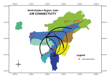
Fig. 6: Air Connectivity of NER
Source: Public Information Domain, web site: www.aai.aero
Air connectivity in the North Eastern Region
As part of development of airways connectivity of NER, a few aerodromes were built up in this region during World War II (WW-II) when the eastern war front reached the Indo-Myanmar border. During this period a small aerodrome was built by allied forces at Kahikuchi (Near Guwahati), Mohanbari (Dibrugarh), Salanibari ( Tezpur), Rawraiya (Jorhat), Lilabari (North Lakhimpur), Dimapur and Imphal. After independence some of these airports were used by private companies for personal use. But it was only after the nationalization of commercial air transport in India that Indian Air Line Corporation took over the service and new air-ports were operated at Dimapur, Kumbhirgram (Near Silchar) and Agartala. The airport of Guwahati at Kahikuchi is also shifted to Borjhar. Besides these developments in regard to the establishment of airports in NER, a number of smaller air-ports have also been started connecting places like Ziro and Tezu in Arunachal Pradesh, Umroi near Shillong, Tuirial (Aizawl), and Kailashahar and Kamalpur in Tripura. At present there are only 6 domestic airports which are in operation. But it is disheartening to note that there are 7 domestic airports which are still non-operational. These are Rupsi, Shella, Kamalpur, Khowai, Lengpui, Kailashahar, Passighat and Tezu. There is not a single custom airport in the region. The number of operational civil enclave is only 3 i.e. Tezpur, Jorhat and Silchar. These facts further highlight that the existing potential of the air ports are not utilized and up graded properly to meet the growing needs of the region.
The volume of increase in aircraft movement in 2010-2011 in relation to 2004-2005 is 104 % that is a more than double rise during these six years.
In Fig. 6, the connectivity of the existing airports in NER is shown with relative importance of services by thin to thick lines. The thinnest one represents single flight from one to other destination. It is observed that the highest number of flights are available between Guwahati and Imphal. Silchar, Dibrugarh and Agartala are connected by two flights each from Guwahati. Jorhat and Aizawl have one flight each to and from Guwahati. It is interesting to note that the rest of the airports are not connected to each other. Only helicopter services provided by private company and Indian Air Force are available to these locations.
The frequency of helicopter services is also negligible. So, further initiative is on to build more air-port in the region for better connectivity. Hence, the mobility in between many airports is restricted due to non-availability of infrastructure needed for air services. Many of the airports in the NER are serving the defense needs only ignoring the requirements of such services for the common people. As a result of which the economic growth and tourism development are stagnant including the exploitation of resources and development of industries in the region. The far-flung places of Arunachal, Manipur and Mizoram need domestic, international and custom airports for both strategic and economic reasons. Guwahati, not only a major commercial and educational hub of Assam but also the home of the premiere educational institution such as IIT Guwahati, Guwahati University and Cotton College, Engineering College and many private universities, links other states of the NER. It is also a centre of cultural activities and sporting events of NER. Table-1 vividly shows the existing profile of airports and civil enclaves in the North Eastern Region of India.
The terrain makes air connectivity not just an option but an absolute necessity for tourism and economic development. Road and railways are highly capital intensive than development of air infrastructure.
It also highlights the operational and non-operational airports along with the existing facilities and their apron capacity and dimensions. From Table-1, it can be observed that except a few domestic airports in the region, the rest of the airports are not equipped with required dimensions to handle traffic and passengers. The LGB International Airport at Borjhar, about 20 km west of the Guwahati city is the only airport which has been playing pivotal role in shaping air connectivity in the North Eastern Region of India.
In conclusion for India’s northeast, development of air connectivity is a challenge and will have a key role to play in improving the overall connectivity to and from the region. To expedite the slogging scenario of air connectivity, fulfilling of infrastructural gaps is urgent to develop non- functional air port at Daporizo Zero, Passighat, Along, Rupsi and Kamalpur, taking into consideration the regions strategic importance. There is an urgent need to expand helipads and grounds for helicopter service mainly in remote areas of the region. Improvement of cargo handling, night landing of aircrafts and halt facilities to the passenger, establishing budgeted airport hotel, augmented training facility to the local manpower by setting up of aviation training institutes are just some immediate concerns. There are 12 airports where airstrips are currently not in use. This issue should be addressed properly for better air connectivity and to harness the tourist potential and the growth of economy of the NER. The growing air connectivity in the region has great significance to integrate the diverse society, culture and various sectors of economy such as agriculture, industry, tourism and service. Look East Policy launched by Government of India in 1991 is one of the initiatives towards fulfillment of the dreams of people in this region. The centre sanctioned Rs 53,000 crores in the last budget for the all round development of the region.
